


Hamilton County is one of the largest counties in New York state and it does not fall short for hiking opportunities. To choose just three would be a tough proposition. The hiking trails of the county are not all rated for a family-friendly adventure — some are quite difficult and some are as easy as a stroll to your local food mart. Below please take a gander at three hikes that fit all fields of adventure — easy, moderate, and strenuous.

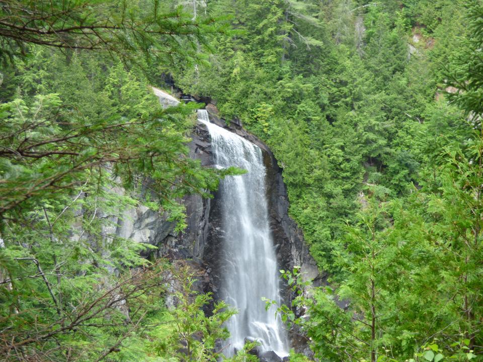
Death Falls, a.k.a. Secret Falls
– 0.75 miles, round trip
This might not be the most romantic of names for destinations, and maybe a bit Halloweenish, but it sure is worth the easy stroll.
Passing by the canary yellow state barrier you will be on an old access road that brings you through a grass field with an attractive wetland to your left, which is part of Death Brook. As you continue by the wetland the sweet smells of Adirondack balsams will fill your nose and the soft sounds of the local birds will sing you a song.
As you continue you may notice a split in the trail. It's not terribly obvious, but present nonetheless. Right leads above the falls and eventually to Camp Sagamore. This trail is not marked and not recommended. The left fork leads to the base of the falls. At this point you should be able to hear the water pouring to the rocks below. There is a small stream crossing where you can see the falls to the right.

How to get there
From the intersection of Routes 28 and 30 in the town of Blue Mountain Lake, follow Route 30 toward Raquette Lake. Continue on Route 28 for just under 10 miles to a gated dirt road on the left. This gated dirt road is not marked as a trailhead and is located near the entrance to Golden Beach State Campground.

OK Slip Falls
– 6.0 miles round trip to view of falls, 8 miles round trip to the base of the falls
The first section follows the original trail and is noticeably packed down from heavy use . In a half mile the trail splits — left is the continuation of the Ross Pond trail and right leads to OK Slip Falls. The trail from here still looks and feels quite new in comparison and travels over undulating hills and past an attractive wetland. At 2 miles from Route 28 you will come to a dirt road. Hang a left on the dirt road and continue for a couple hundred feet where you will jump back into the woods to the right. The remaining distance of roughly 1 mile is along an old carriage road. Look for a sign that shows the right-hand turn that leads a short distance to the falls.
To continue on to the Hudson River and to the base of the falls, head left. Continuing from here however makes this hike more of a strenuous endeavor than a moderate one. Approaching the river is very steep and slippery, so care should be taken on this descent. This trail section will end at the Hudson River, but many who venture this far continue a bit further upstream to get a better view of the falls. The climb out is the strenuous part and the elevation change can be quite exhausting to some hikers.
How to get there
This trail is located 7.5 miles east of the intersection of Routes 30 and 28 in Indian Lake. Look for a wooden DEC sign for the Hudson Gorge Wilderness Area at the parking lot. The trailhead is located on the north side of Route 28, 0.2 mile west of the actual parking area. You will need to walk along the highway toward Indian Lake for 0.2 mile and cross the road to reach the trailhead. There is a small wooden sign located there for Ross Pond and another for OK Slip Falls.

Snowy Mountain
– 7.8 miles, round trip
From the trailhead you will may be surprised at how mellow the trail is, but don't let that fool you — it gets much more strenuous as you approach the foot of the mountain. The easy, rolling hills of this trail will last quite some time as you hike through an attractive hardwood landscape. You will eventually start to hear Beaver Brook to your right, and then you'll cross it near a small set of steps.
Make a hard left after the crossing and start climbing up through a shallow pass, crossing the brook on a couple more occasions as you go. The terrain gets steeper as you continue and only lets up on occasion. Use this lull to refresh and rehydrate before you jump back in again. As you near the top you will come to a very steep section with rough footing followed by a plateau area. To the right you can venture over to an outstanding overlook, but be very careful here as it can be slippery. The trail continues past the plateau and moderately climbs to the true summit, where the fire tower sits. There is no view from the summit floor — you will need to climb the tower's many flights of stairs to get any additional views.

How to Get There
From the intersection of Route 28 and Route 30 in Indian Lake follow Route 30 toward Speculator. Continue for just over 7 miles to the trailhead on the right. Parking is on the left.
After your hike, why not get some dinner and enjoy a relaxing stay at one of our many lodging options!
This week our bloggers highlight favorite ADK hikes:


