


Stress. It’s just hard to avoid no matter what you do in your life. The solution? Nature. Just being outside for as little as fifteen minutes, surrounded by as much of the natural world as possible, has been proven to drastically reduce stress levels. Here in the Adirondacks, we’re lucky to be tucked in a cocoon of pure wilderness and beautiful scenery. So the next time you feel yourself start to fret, just stop. Take a breath. And then get yourself to one of these quickie hikes. You will feel your troubles simply whoosh away like a forest breeze. Each of these little jaunts is just a mile or less, round trip, with a variety of different types of destinations. Since each of these little trails are so short, consider pairing them with a visit to a local eatery!

1. Long Lake Nature Trail [Long Lake] - Round Trip = .2 miles
Hidden behind Long Lake School, the Town Library and several businesses in Long Lake is a little stretch of solitude on the east shore of Jennings Park Pond. This short walk will take you from northwest edge of the ball field to the back of The Adirondack Hotel. Time your walk so that you arrive in time for lunch or cocktails at the hotel.
To get there: In Long Lake, walk to the top northwest corner of the Town of Long Lake ball field. The Nature Trail starts at the edge of the field and along Jennings Park Pond.

2. Auger Falls [Speculator] - Round Trip = .5 miles (with a possible loop of 1.2 miles)
Another spot featured in the Waterfall Challenge, Auger Falls is an amazing series of cascading waterfalls that extends for about a half mile along the Sacandaga River. From the start of the falls, the drops intensify as you walk downstream, completely drowning out any sounds from the outside world.
To get there: From the corner of NYS Routes 30 and 8 north of Wells, travel north towards Speculator for 1.7 miles. The sign for Auger Falls will be on your right. Follow the dirt road to a large parking area. At the north end of the parking lot, follow the trail north to the river. Walk downstream along the river. There are many viewpoints along the way but be careful of the steep edge as it can get slippery. At any point, turn around for a shorter walk or continue around for the full loop.

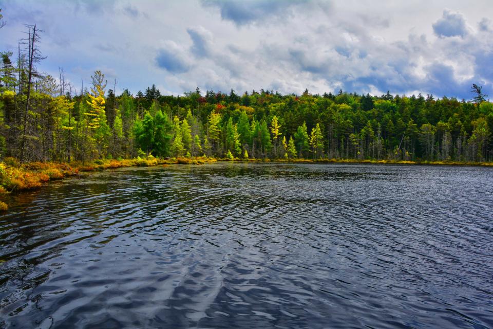
3. Ferd’s Bog [Inlet] - Round Trip = .6 miles
Named after Ferdinand LaFrance, an area birder who documented a rare woodpecker in this area in the 1970s, Ferd’s Bog is filled with tamarack trees, sphagnum moss, pitcher plants as well as numerous boreal birds. The trail takes you out onto a boardwalk which extends out into the bog for great viewing. Even families with young kids will be able to do this entire hike in about thirty minutes.
To get there: From Arrowhead Park in Inlet, drive 1.9 miles towards Eagle Bay and Old Forge. Uncas Road will be on your right. Travel 3.2 miles on the Uncas Road to a small parking area on your left. The trailhead sign and register are easily visible from the parking area.

4. Sprague Pond [Indian Lake] - Round Trip = .6 miles
Located on the Cedar River Road west of Indian Lake, Sprague Pond is an easy hike for any level of hiker. The pond is popular with fisherman and paddlers in the summer and snowshoers in the winter. Views of the Blue Ridge Wilderness area to the north are beautiful and, if you work your way around the west side of the pond, you can see Sawyer Mountain to the east.
To get there: Take Cedar River Road, in Indian Lake, west for 4.5 miles. Trailhead will be on your right. There is a small parking area on the right, just past the trailhead, as well as a pull off parking area directly across from the trailhead.

5. Sand Lake [Piseco] - Round Trip = .6 miles
This quiet little trail takes you to the north tip of Sand Lake in Piseco. Three campsites mark the start of the trail and there is one designated campsite directly on the lake at the end of the trail.
To get there: From the intersection of Routes 30 and 8 in the town of Speculator, drive west on Route 8 towards Piseco for 12.2 miles. Turn left onto Route 10. Drive 1.2 miles to Powley Road and turn right. Drive 2.1 miles on Powley Road and look for campsites on left side of road. Trailhead is to the left of the campsite that is farthest from the road.
6. Helldiver Pond [Moose River Plains / Inlet] - Round Trip = .8 miles
Located in the middle of the Moose River Recreation Area, Helldiver Pond is well known for the large bull moose that often show up in the early morning hours. This flat gravel and crushed rock trail is accessible and ends at an accessible dock for fishing or pond gazing. The water drops off quite deep at the end of the dock.
To get there: Take Limekiln Road off Route 28, just outside the Town of Inlet. Drive 2 miles and turn left onto Moose River Plains Road. This is a seasonal dirt road, open to vehicles until the end of hunting season, the first weekend in December. Driving can be slow, so please take your time. Drive along Moose River Plains Road for 9.6 miles. The Trail for Helldiver will be on your right and is marked with a large DEC sign. Continue along this road to the parking area. Trailhead is clearly marked.

Try these relaxing hikes and more. Plan your stay today. There's plenty to explore in the Adirondacks!
This week in ADK news:


